The following is an excerpt from: (2013) The Collins Site (3WA1): Exploring Architectural Variation in the Western Ozark Highlands. Southeastern Archaeology 32:70-84.
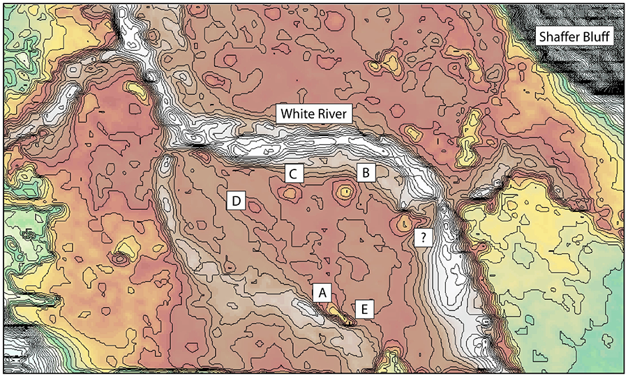
The Collins site is located within a narrow, alluvial valley in the Ozark Highlands near the convergence of the Springfield Plateau and Boston Mountains. The White River cuts through this valley and the site is positioned on the southern bank of the East Fork of the White River in Elkins, Arkansas.
The location of the Collins site geographically corresponds to a possible cultural boundary described in Caddo literature as the northern Caddo area. In this description, the northern Caddo area includes the Arkansas Valley lowlands from the Carden Bottom area (near the Petit Jean Mountain) as the eastern extent, to the confluence of the Neosho and Elk rivers in northeast Oklahoma as the western extent, with the Ozark Highlands of northeast Oklahoma, northwest Arkansas, and southwest Missouri between the two.
Conversely, it has been argued that the Ozark Highland region should not be examined in terms of a generalized northern Caddo area. But that it rather represents a complex region of three culturally and biologically distinct populations: The Ouachita Mountain region, the Arkansas River Valley region, and the Ozark Highland region. These distinctions are ceremonialism, burial patterns, social organization, art styles, mound types, and pottery. Using this refined geo-cultural distinction, the Collins site is located in the Ozark Highland region, along with several other contemporaneous mound and non-mound sites in northeast Oklahoma, northwest Arkansas, and southwest Missouri.
The site contains five fairly low-relief earthen mounds that are situated on a bedrock controlled low terrace underlain by an earlier point-bar deposit. During heavy spring rains, the East Fork of the White River overflows the banks and floods the site. The current property owner stated that on more than one occasion, the summits of the mounds have offered unsuspecting cattle a refuge from flood water.
The shifting channel of the White River occurred relatively rapidly, but the East Fork is most likely to have been in roughly the same position as it is now during occupation of the Collins Site. Historic photos of the site from 1941 reveal fairly minor agricultural impacts, suggesting the preservation of archaeological features is relatively stable.
Additionally, the site is situated below Shaffer Bluff, a humpback-shaped elevation that rises out of the White River floodplain and represents an easily recognized feature on the landscape. The five mounds are located within an area bounded by the current river channel to the north and east and a former channel to the south and west. Mounds B, C, and D are along the current channel. Mounds A and E are located on a former channel. Dimensions of the mounds range from 21 to 51 meters in width and 0.5 to 3 meters in height, although their height has certainly been reduced as a result of plowing. It is also likely that the mound width was somewhat less, owing to lateral spreading of mound sediment related to plowing.
HISTORY OF INVESTIGATIONS
Although it is one of the few multi-mound sites located in the Ozark Highlands, little is known about the archaeology of the Collins site. Formal excavations have yet to be conducted at the site, although there has been some documented work, both semi-systematic and looting. The University of Arkansas Museum files contain a few terse entries that suggest the museum conducted excavations in the 1930s, as well as a few photographs from 1941 that show a trench dug in one of the southern mounds, probably Mound A. Unfortunately, no reports were produced from any of these early excavations. In 1980, Arkansas Archeological Survey staff encountered recovered carbonized wood and thatching after a looting episode in 1980. A considerable amount of burned clay and charcoal was found in the backfill from Mound E likely indicating a structure.
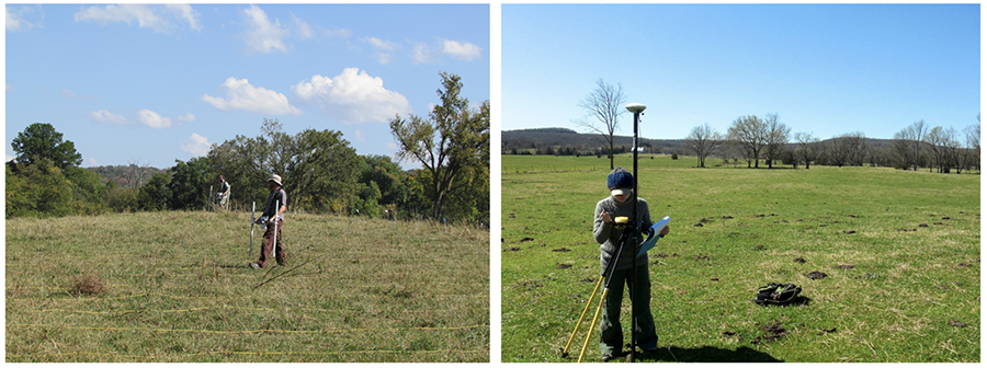
Our recent investigations at Collins have focused on gathering information on a landscape scale and attempting to determine the presence of structures on or within the Mounds B, C, and D on the northern portion of the site. Given the nature of carbonized wood and thatch discovered within Mound E in 1980, it was hoped that a geophysical survey would provide information on architectural features. The survey was restricted to the northern portion of the site owing to landowner access.
GEOPHYSICAL METHODS
Two Bartington magnetic gradiometers were employed for the bulk of data collection. The use of this instrument allows for relatively quick data collection with a high spatial resolution over a large area. A magnetic gradiometer measures remnant magnetism, or the , and thermoremant magnetism, the enhanced magnetic field as a product of high heat burning. It is a passive technology meaning that an external electromagnetic field is not applied in order to magnetize the subsurface materials.
The detection of patterns that define the geophysical signatures is a primary goal of near- surface geophysical surveys. Because geometric shapes such as lines, right angles, rectangles, circles, and ellipses are rarely found in nature, anomalous signatures with these shapes tend to be anthropogenic in origin.
A Trimble GeoXH GPS receiver with Zephyr Antenna was also utilized to accurately map in the two established grid datum, one on Mound B and the second on Mound C. A selection of survey grid corners was also mapped in order to georeference the magnetic gradiometry data into real-world UTM coordinates.
SURVEY AREA AND RESULTS
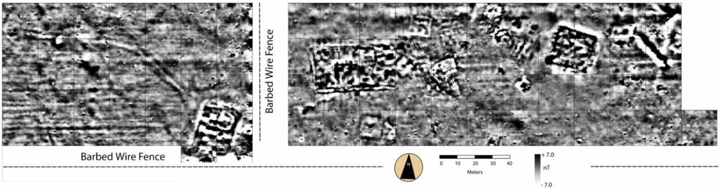
As mentioned, the survey area was concentrated on the northern portion of the site around Mounds B, C, and D owing to landowner access and current permission to only this portion of the site. A total survey area of 2.92 hectares (7.22 acres) was oriented to cover this trio of mounds and the area between and around them in hopes of demarcating the northernmost extent of the site. A 20-meter wide stretch between Mounds C and D was purposefully un-surveyed due to the presence of a barbed wire fence.
Transects were spaced at half-meter intervals with a sampling density along each transect of eight samples per meter or 160 samples per transect. Data collection commenced in the southwest corner of each grid and continued toward the north, with consecutive transects collected in a zigzag fashion. A total of 467,200 samples or measurements were collected while walking a total of 18 miles!
Architecture: Mound B Area
The data from the eastern-most portion of the survey area show a number of likely structures located both on- and off-mound. A large, unambiguous, square structure approximately 20 x 20 meters is almost perfectly centered on or within Mound B. The large structure is oriented a few degrees of north with a possible extended opening or access point facing toward what is likely a large plaza area. The mound itself contains a topographic slope on the south, as evidenced in the contour data, which is associated with the possible opening and might represent a constructed ramp down into the plaza area. There are several high magnetic anomalies within the large Mound B structure that might represent burned roof debris or internal architectural features. Interestingly, the data also reveal a likely smaller square-shaped structure measuring approximately 10 x 10 meters and situated on a slight topographic rise attached to the northeast of Mound B. Might this be evidence of a second smaller mound conjoined to Mound B? Conjoined mounds have been documented in the Ozark Highland region at the Norman and Harlan multi-mound sites.
Several other anomalies, interpreted as possible rectangular and circular structures, are apparent to the west of Mound B. The rectangular anomalies are approximately 5 x 5 on a side. A possible circular structure is roughly 5 meters in diameter. Most of these contain a centralized high magnetic anomaly, which likely represents an internal central hearth.
Architecture: Mound C Area
The survey area around Mound C contains several anthropogenic anomalies and is just as informative as the Mound B area. The most prominent anomaly is a large enclosure or structure, centrally located on or within Mound C containing a possible designated entrance facing to the south. The anomaly is approximately 45 x 30 meters in size and looks to contain several internal architectural features, such as the possibility of rectangular and circular structures. As a result, it appears that this feature may be an enclosure containing separate internal architecture. An interesting attribute related to the anomalies that constitute the outline of the enclosure or structure is the possibility of wall trench or double-walled single post architecture as evidenced by the pattern of high magnetic linear anomalies with a low magnetic signature running down the center.
It should also be noted that the shape of Mound C, with a possible ramp to the south, is roughly the same shape as the geophysical anomaly that is, fairly rectilinear in form suggesting that the anomaly is not on the mound but might represent a sub-mound structure, subsequently buried by mound fill and taking on the shape of the buried structure.
Several additional anomalies, interpreted as possible rectangular structures, are apparent to the north, east, and south of Mound C. They are roughly 5 x 5 meters. In terms of magnetic gradiometry signature, they are much less pronounced than those that define the structure associated with Mound C, suggesting they were either not burned or possibly deconstructed before burning.
Architecture: Mound D Area
The Mound D area is bifurcated on both the east and south by a barbed wire fence. The mound itself is located in the southeast corner of this geophysical block and partially extends beyond the fence to the south. As with Mounds B and C, there is clear evidence of yet another structure either on or within the mound. The rectilinear anomaly associated with Mound D is approximately 30 x 15 meters and is, as with the others, centered with the mound topography. There are no other anomalies that are interpreted as structures in this area; however, some individual anomalies of higher magnetism might represent pits, such as storage pits.
Historic differential land use is identifiable in this area as the east-west running linear anomalies that likely represent former plow furrows running parallel to the barbed wire fence. Additionally, there are several linear anomalies extending more or less northwest to southeast that are undeterminable in origin. The largest and most prominent of these terminates at the base of Mound D. What this anomaly represents is unknown, but it could be a possible trail related to the original occupation, a contemporary historic road, or a natural wash draining to the river terrace located another approximately 100 meters to the north. No additional structural anomalies are evident around Mound D, suggesting that this area is possibly the northwest extent of the immediate Collins mound group.
COMPARATIVE ARCHITECTURE
Within the Ozark Highland region, there are no other geophysical surveys with which to compare our results and thus we offer a comparative discussion based on excavations from other sites in the region.
In terms of possible function or use of the large mound structures identified at Collins, mound excavations at the sites of Harlan, Huntsville, and Goforth-Saindon have uncovered sub-mound Harlan-style charnel houses. Harlan-style charnel houses were mortuary structures used in accordance with a deliberate mortuary ritual cycle. As part of this cycle, a charnel house was set on fire, destroyed, and subsequently buried with mound fill only to repeat this cycle again over the now buried mortuary structure. Based on the description of the structural composition and ritual attributes associated with charnel house architecture, it is possible that one or more of the mound structures at the Collins site could represent a structure of similar function.
A second architectural attribute that might constitute the structures at the Collins site is the use of wall trench or double-wall posts. At the Reed site, two superimposed rectilinear structures, one of which contains a series of double posts on two walls, have been documented. At the School Land II site, a single rectangular structure is recorded as a double-walled structure with an extended entranceway. Both the Reed and School Land II sites were excavated as part of WPA excavations in the 1930s and 40s.
A third attribute is the likelihood of internal posts for structural support. As shown in the geophysical data, there are at least two structures that contain high magnetic anomalies oriented that they might represent large internal posts. Internal posts have been found at several sites in the Ozark Highlands, such as Harlan, School Land I, and Reed.
CONCLUSIONS AND FUTURE DIRECTIONS
Some initial conclusions that can be made from this survey are that the magnetometry data show several anomalies, likely cultural in origin, that are clearly associated with mound topography. These anomalies likely represent large mound top structures or enclosures or sub- mound structures. The largest anomaly, associated with Mound C, likely has separate internal architecture. And throughout the survey area, numerous off-mound anomalies likely represent rectangular structures, some with central hearths.
Future directions for research at the Collins site include additional magnetometry survey in the southern portion over Mounds A and E and the plaza area between these two mound groups. Obtaining a complementary geophysical dataset with a method such as ground-penetrating radar would improve the interpretability of the magnetic anomalies across the site, specifically those associated with the mounds, as GPR returns a three-dimensional volume of data allowing the depth of features to be determined.
Lastly, excavation, stratigraphic mapping, and the dating of excavated materials would provide a more empirical understanding of the nature of the structures found using geophysics and allow for more comprehensive comparisons of architectural variation between other sites within the Ozark Highlands.
For more information:
| Bell, Robert E. 1984 Arkansas Valley Caddoan: The Harlan Phase. In Prehistory of Oklahoma, edited by Robert E. Bell, pp. 221-240. Academic Press, New York. Duffield, Lathel F. 1969 Vertebrate Faunal Remains from the School Land I and School Land II Sites, Delaware County, Oklahoma. Bulletin of The Oklahoma Anthropological Society 18:47-65. Guccione, Margaret J., and Barbara Rieper 1988 Late Quaternary history of the White River, Fayetteville, Arkansas. The Compass: Earth Science Journal of Sigma Gamma Epsilon 65(4):199-206. Kay, Marvin, George Sabo III, and Ralph Merletti 1989 Late Prehistoric Settlement Patterning: A View from Three Caddoan Civic-ceremonial Centers in Northwest Arkansas. In Contributions to Spiro Archaeology: Mound Excavations and Regional Perspectives, edited by J. Daniel Rogers, Don Wyckoff, Dennis A. Peterson, pp. 129-157. Oklahoma Archaeological Survey, Norman. Kay, Marvin, and George Sabo III 2006 Mortuary Ritual and Winter Solstice Imagery of the Harlan-style Charnel House. Southeastern Archaeology 25(1):29-47. Kvamme, Kenneth L. 2003 Geophysical Surveys as Landscape Archaeology. American Antiquity 68(3):435-457. Perttula, Timothy K. 1992 “The Caddo Nation”: Archaeological and Ethnohistoric Perspectives. University of Texas Press, Austin. Regnier, Amanda L., Scott W. Hammerstedt, and Sheila Bobalik Savage 2019 The Ritual Landscape of Late Precontact Eastern Oklahoma: Archaeology from the WPA Era until Today. University Alabama Press. Schambach, Frank F. 1990 The “Northern Caddo Area” was not Caddoan. Caddoan Archaeology 1(4):2-6. Vogel, Gregory, Marvin Kay, and Louis Vogele, Jr. 2005 A Platform Mound at the Norman Site (34WG2), Eastern Oklahoma. Southeastern Archaeology 24(1):28-45. |