The following is an excerpt from: (2014) Results from Geophysical Survey at Whiteside Cemetery on the Campus of Southern Illinois University. Report submitted to Dr. Julie Zimmermann, Southern Illinois University.
On June 20, 2014 students from the Arizona State University Field School (ASUFS) hosted at the Center for American Archeology (CAA) in Kampsville, Illinois conducted a small survey of the Whiteside Cemetery on the campus of the Southern Illinois University Edwardsville (SIUE). The purpose of the survey was two-fold: (1) to evaluate the extent of burial deposits that are a part of the Whiteside Cemetery and their relationship to surface markers; (2) as a form of reciprocity related to the generous offer to use SIUE geophysical equipment (magnetometer and resistivity) as part of the ASUFS instructional surveys during two-weeks in June 2014.
SURVEY AREA
The Whiteside Cemetery is located at the top of an elevated landform situated above the Cahokia Creek drainage. On the ridge of the landform is a level surface oriented a few degrees from north, which slopes downward on the east, west, and south sides. To the north the landform continues into a grove of trees. The level area is about 30 meters in width to the north and about 10 meters in width to the south. Vegetation at the time of survey was tall prairie grass mixed with thorny scrub brush. A single 20×20 meter geophysical grid was arbitrarily established with the Whiteside Cemetery oriented in the center. About 5-meters on the east and about 1-meter on the west side of the grid was downslope.
RESULTS AND INTERPREATIONS
Both magnetometry and resistivity surveys were conducted. Results from each technology correlate nicely and delineate the extent of the Whiteside Cemetery.
Magnetic gradiometry is measured as the net effect of magnetic variations in the shallow subsurface soil matrix (approximately 1-2 meters). The measurement of magnetic gradiometry is conducted using a passive approach, in that the instrumentation measures the naturally occurring magnetic field without emitting a magnetic field, pulse, or current into the subsurfacE. While earlier instrumentation measured the total magnetic field, which required the manual differencing of diurnal changes measured by a remote sensor, magnetic gradiometers do not report the total magnetic field strength. Instead, magnetic gradiometers calculate the real-time difference of the two vertically separated sensors as the survey is conducted and measurements are simultaneously being recorded. This difference yields a vertical gradient measurement of the magnetic field free of diurnal variations. The vertical gradient is measured and reported in nanoteslas (nT; 10-9 Tesla).
The magnetometry survey results reveal numerous high magnetic subsurface anomalies as high-low dipole readings in a cluster associated with the mapped surface stones. These anomalies represent the buried remains of ferrous metal objects. The metal debris is likely related to several possible features: (1) rebar within the headstone foundations; (2) the presence of metal caskets or hardware; (3) metal objects buried with the individuals. Additionally, surface investigations identified the remains of a barbed-wire fence around the cemetery. Broken barbed-wire pieces would also contribute to high-low metal dipole readings, although not as significant as large metal items related to burials. The light higher magnetic outline “halo” is likely related to the former barbed-wire fence.
Overall, the cluster of magnetic anomalies correlates to the surface stones, although a few anomalies to the northwest of the surface stones do not have surface correlates. These could represent unmarked burials or some of the metal debris could be related to more recent mowing on the landform and broken parts being “tossed aside” into the cemetery area. A single high magnetic anomaly is to the northwest and is separate from the metallic cluster. This outlier could represent discarded mowing or farming parts since it is situated some distance outside the proposed former barbed-wire fence. With exception to the outlier, all magnetic anomalies are located within the possible former barbed-wire fence anomaly.
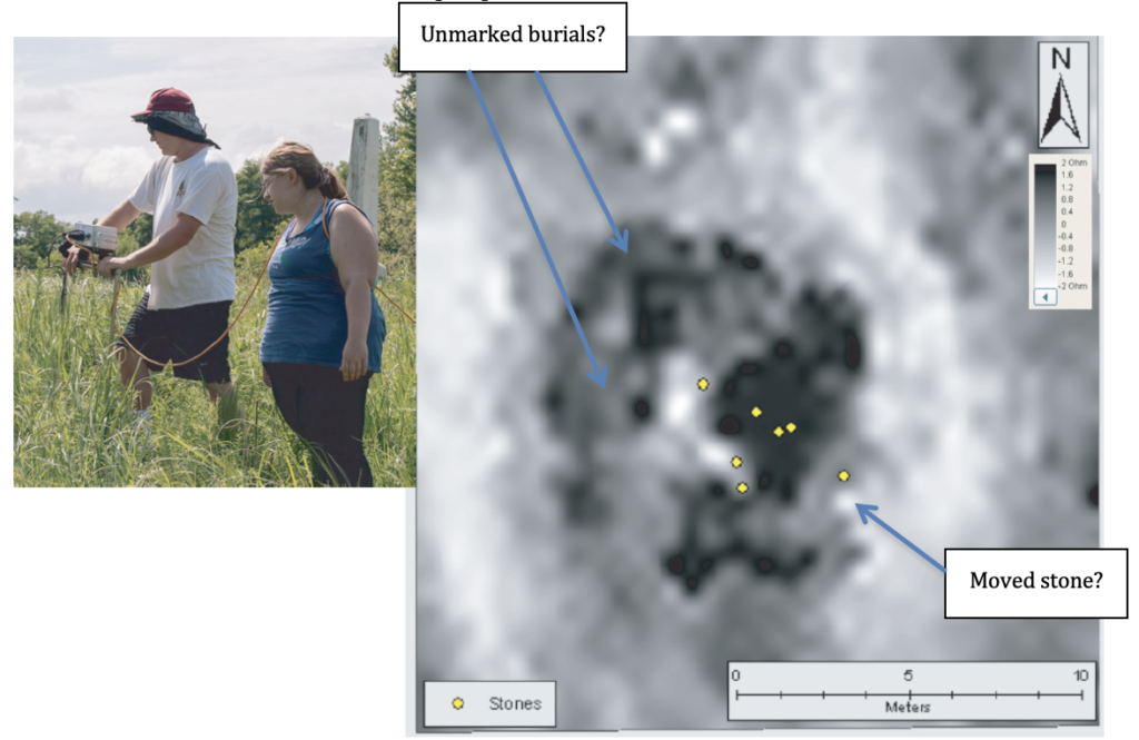
A single mapped surface stone to the southeast and within the possible former fence does not have a corresponding high-low dipole reading. This suggests that the stone has been moved and is no longer associated with a burial. Surface observations reveal several stone corner markers that have been moved. Several stones are broken and scattered around the standing stones.

Electrical resistance surveys measure the level of resistance (R) in the subsurface by injecting a current (I) into the ground using a low voltage (V) resistance meter. The ratio of current to voltage defines resistance and is expressed by Ohm’s Law, mathematically stating that R=I/V. While resistance is an electrical quality, resistivity is the actual specific property of the material. Its conversion allows for the “resistance of different materials to be compared in a standardized way” (Clark 1996:27). Electrical resistivity is measured and reported in ohm-meters.
Variations in resistance measurements are based on the principle that geological features hold different materials and different amounts of moisture. Both exhibit varying levels of resistance to an electrical current, and the latter has a particularly large effect in archaeological sites. These varying levels of resistance can be influenced through anthropogenic (and natural) processes that alter the compaction of the soil resulting in a change of soil moisture properties. A measurement of high resistance (low conductivity) might represent a shallow subsurface of compressed soil matrix such as a house floor where porosity is decreased and evaporation is elevated. In contrast, a measurement of low resistance (high conductivity) might represent a storage pit or house depression where moisture has accumulated into a more porous soil matrix and is less likely to evaporate. Certain materials, like stone or sand, are known to exhibit high electrical resistance.
The resistivity survey results record variations in soil resistance related to changes in porosity associated with the Whiteside Cemetery burial pits. Similar to the magnetic results, anomalies are clustered in association with the surface stones with several additional anomalies situated to the northwest of the surface stones. An interesting “right-angle” square anomaly (with a central anomaly) is located to the northwest of the stones and is likely related to an unmarked burial. A separate isolated “square” anomaly is situated to the west of the surface stones and may also represent an unmarked burial. As revealed in the magnetic data, these areas contain high-low dipole anomalies further suggesting that the high resistance anomalies represent the presence of unmarked burials to the northwest of the surface stones. The linear low resistance readings that border the cemetery to the east and west area are associated with the sloping landscape and differential moisture accumulation related to changes in soil chemistry along the slope. These changes could be associated with historic landscape modifications such as repeated plowing or mowing around the cemetery boundary. The orientation of high resistance anomalies is consistent with the proposed former barbed-wire fence.
CONCLUSIONS
The visible cluster of surface stones and subsurface magnetic and resistivity anomalies clearly demonstrate the primary extent of the Whiteside Cemetery within a former fenced area. While many of the anomalies are associated with stones visible on the surface, several anomalies likely represent unmarked burials where the stones have either been moved or damaged. Several stones on the surface are damaged and seemingly not in their original location. These stones might be associated with the anomalies interpreted as unmarked burials to the northwest of the mapped surface stones.
For more information:
| Clark, Anthony 1996 Seeing Beneath the Soil: Prospecting Methods in Archaeology (New Edition). Revised Edition. B. T. Batsford Ltd., London Kvamme, Kenneth L. 2006 Magnetometry: Nature’s Gift to Archaeology. In Remote Sensing in Archaeology, An Explicitly North American Perspective, edited by Jay K. Johnson, pp. 205-233. University of Alabama Press, Tuscaloosa, Alabama. McKinnon, Duncan P., and Bryan S. Haley 2017 Archaeological Remote Sensing in North America: Innovative Techniques for Anthropological Applications, edited by Duncan P. McKinnon and Bryan S. Haley. University of Alabama Press. Somers, Lewis 2006 Resistivity Survey. In Remote Sensing in Archaeology: An Explicitly North American Perspective, edited by Jay K. Johnson, pp. 109-129. University of Alabama Press, Tuscaloosa, Alabama. |