The following is an excerpt from: (2015) A Symbolic and Sacred Landscape: The Confederate Cemetery in Fayetteville, Arkansas. In The Hidden Diversity: Historical Archaeology in Arkansas, edited by Carl G. Drexler, pp. 45-56. University of Tennessee Press.
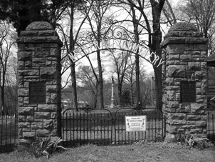
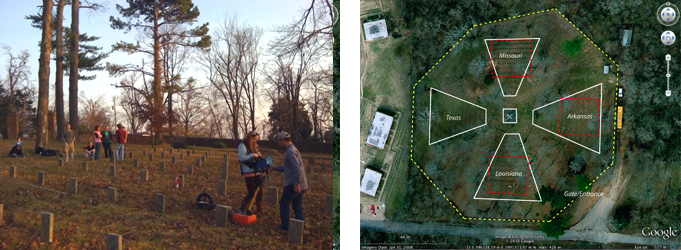
The Confederate cemetery in Fayetteville, Arkansas represents a landscape of valor, a landscape of honor, and a sacred landscape of states’ rights. The cemetery is on the National Register of Historic Places and has been, and still is, owned and cared for by the Southern Memorial Association since their formation in 1872 and the cemetery construction and dedication in 1873. Curious visitors that seek out this quiet and peaceful site are greeted by an ornate iron gate, flanked by two massive stone pillars, one of which has a sign warning that trespassers will be punished to the extent of the law, although such regulation is not enforced today. Beyond the gate, are four large burial plots, oriented at cardinal directions and containing soldiers from the states of Arkansas, Louisiana, Missouri, and Texas, among others. In the center is a large cornerstone monument, atop which stands the statue of a Confederate soldier guarding his fallen comrades.
The use of both historical and geophysical data demonstrates that the cemetery does indeed represent a landscape of states’ rights. Historical documents reveal the construction of the cemetery focused on an urgency to honor those confederate soldiers who fought for the southern cause of state independence and rights; to provide them a place to rest in burial plots that correlate to the geographical location of the states associated with each soldier. Geophysical data reveal that soldiers, buried throughout the battlefields of Pea Ridge and Prairie Grove, were exhumed and reburied at the Confederate cemetery, not as mass burials within each burial plot, as we considered when first proposing this research, but rather buried individually in an orderly and ritualistic manner. The central monument, with the large confederate soldier statue atop and the seemingly defensive position of the marble artillery at the base, suggests symbolism concerning the militaristic protection, throughout time, of those that are buried within the sacred cemetery space. If nothing more, the Confederate cemetery as defined by the women of the Southern Memorial Association, represents “a tangible reminder of the brave men who died for a way of life they held dear and the proud women who loved and honored them.” Even today, every June 10th on the anniversary of the dedication of the cemetery in 1873, the Southern Memorial Association hosts Southern Memorial Days, where community members flock to the cemetery grounds and continue to honor and pay respect to those buried within the cemetery.
HISTORICAL DATA
Discussions related to the creation of a Confederate cemetery first began in June 1872, ten years after the battles of Prairie Grove and Pea Ridge, where thousands of confederate soldiers lost their lives and were hastily buried where they fell.
In the June 8, 1872 edition of the Fayetteville Weekly Democrat, a “Call to the Ladies” was posted, respectfully requesting a meeting of post-Civil War southern women to come together and remedy the “culpable neglect of our brethren who lie around and about us in weed-covered and unknown graves.”
This first meeting, attended by about 40 women, established the Washington County division of the Southern Memorial Association – a group of women dedicated to “see that those who gave their lives for the greatest cause the world has ever known, must live forever in the hearts of the Southern people”. Their mission was to locate a plot of land, through community contribution, where confederate soldiers who perished during the battles in northwest Arkansas could be re-interred and given a final resting place.
On March 1, 1873, in anticipation of the purchase of land, the ladies of the Southern Memorial Association hosted a benefit to raise funds for the building of a wooden fence. The event, comprised of individuals contributing tableaux, charades, and musicianship, was well received in the community. The women “succeeded pecuniarily beyond their most sanguine expectations, realizing nearly two hundred dollars.” (about $3,500 today).
On April 11, a plot of “three acres more or less” was purchased on East Mountain above the city of Fayetteville and a wooden fence around the property was constructed quickly thereafter. Between 1885 and 1890, the wooden fence was replaced by a stone wall, about 4-feet tall and constructed of local rough hewn stone. In 1926, the massive stone arch, decorated with iron gates and bronze tablets, was build to formally mark the entrance of the cemetery. Both the stone wall and stone arch still stand today, although are in need of repair in some places.
Throughout April and May 1873, the remains of confederate soldiers were brought from Pea Ridge (for $1.40 for each individual; $24.78) and from Prairie Grove and other battlefields (for $2.50 for each individual; $44.24), by Mr. J.D. Henry to be reburied within the new Confederate cemetery. Various sources estimate that between 600 and 900 individuals were removed from these battlefields, put into new coffins, and are now resting at the cemetery. If one counts the stones that are visible today – that is the marble stones that were erected in 1903 to replace earlier sandstone markers that were placed in 1876 – there are 622, including a few that have inscriptions and date to the 1930s, 40s, and 50s.
On May 31, 1873 the Southern Memorial Association expressed thanks to the citizens of Prairie Grove and Cane Hill for allowing Mr. J.D. Henry and party in taking up the confederate dead and returning them to the cemetery. On the same date, the Southern Memorial Association announced that the cemetery was to be dedicated on June 10.
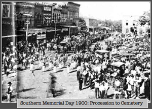
On the 14th of June 1873, the Fayetteville Weekly Democrat reports that over three thousand persons participated in a ceremony that, via a procession one and a half miles long and filled with musicians, ex-confederate soldiers, citizens on foot, on horseback, in carriages and in wagons, marched from the town center up to the location of the Confederate cemetery. The Weekly Democrat continues, “The falling rain that day did not deter little girls, maidens, young ladies, old ladies, youths, young men, and silver-haired men from moving on to pay tribute to the memory of our beloved Southern dead.”
Upon the procession reaching the cemetery, Rev. F.R. Earle, of Cane Hill College, greeted the crowd “who then delivered the dedication address, full of pathos and earnestness”. The crowd then silently filed off throughout the cemetery to honor each and every grave with “flowers, evergreens, and tears… Widows and orphans were there strewing the graves of husbands and fathers who had rendered up their lives in defence [sic] of what they conceived to be right.”
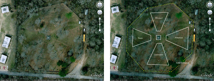
As reported by the Fayetteville Democrat and evidenced on the landscape today, the cemetery is octagonal in shape. It contains four delineated burial plots, each containing the graves of soldiers from the states of Arkansas, Missouri, Louisiana and Texas, although there are a few soldiers buried within these burial plots who served with units from Alabama, Kentucky, Mississippi, and Tennessee. The majority of stones are unmarked. Only a few have inscriptions, mostly on stones that were presumably added much later or of those that mark the burials of individuals buried in the cemetery as late as the 1950s.
Each burial plot is oriented in association with the location of the four primary states. For example, the northern burial plot contains soldiers from Missouri (Missouri being north of Arkansas) and the southern burial plot contains soldiers from Louisiana (Louisiana being south of Arkansas). The western burial plot contains soldiers from Texas (Texas being more of less west of Arkansas, since Oklahoma was considered Indian Territory at that time) and the eastern burial plot contains soldiers from Arkansas (considering that the majority of the state of Arkansas is east of the cemetery location).
GEOPHYSICAL DATA
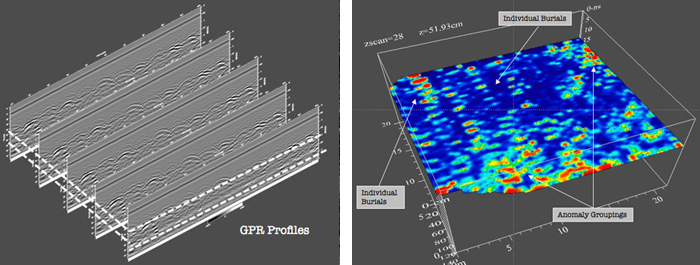
As part of this research, the Confederate cemetery was surveyed in three of the burial plot areas (Missouri, Arkansas and Louisiana) using Ground Penetrating Radar (GPR). In order to have the most dense and organized survey, data were collected along transects that were set up parallel to the headstones (outlined in red below) with transect spacing at approximately 50cm. When a transect was blocked by a row of headstones, the GPR antenna (400Mhz) was pulled as close to the line of stones as possible. The survey areas were confined to the raised portion of the cemetery within each burial area.
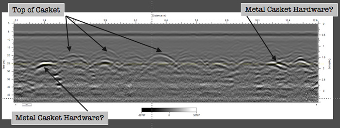
GPR profiles clearly show a series of hyperbolic arcs that represent the location of a material that is different in compositional structure than the material above it. In this instance (a profile from the Missouri Plot), the apex of each one of these arcs likely represents casket components. The strength of the hyperbolas in this image represents the intensity of the radio wave reflected at a certain point. Some of these very strong reflections are certainly pieces of metal, most likely casket hardware, given their context.
These hyperbolic arcs are useful to isolate areas of interest and their geometry can be used to estimate the speed at which the radio waves travel through the ground allowing for a calculation of the actual subsurface depth of anomalies based on the dialectic permittivity of the subsurface matrix. In several of the profiles, like the one shown below, the depth of each hyperbola apex is primarily between 20-30 nanoseconds, or approximately 1.75 – 2.0 meters (6.5 ft) below the surface and likely represent casket hardware at the base of individual grave shafts.
Time slicing of several parallel profiles across the burial plot area produced some compelling results that reveal that soldiers were reburied individually (instead of mass burial within each plot). With time slice processing, data are interpolated between adjacent survey profiles to create a plan map that allows visual representation of anomalies at various depths. In the image below, regularly spaced anomalies, at approximately 52 cm in depth, are clearly identifiable. Each anomaly measures approximately 2 meters (6.5 ft) by 0.75 meters (2.5 ft) and are organized in rows throughout the burial plot area.
Within each burial plot, some groupings of anomalies can be identified. These groupings may represent areas where multiple caskets were concentrated or reburied in haste. Possibly, they might represent larger caskets.