The following is an excerpt from: (2016) Returning to Kamp Mounds (11C12): Results from Geomagnetic Survey and High-Density Topographic Mapping in Calhoun County, Illinois. Midcontinental Journal of Archaeology 41(3):231-254.
The research is part of a larger program focused on the construction of community during Middle Woodland times in the Lower Illinois River Valley (LIV). Three dimensions of LIV sites are investigated – site organization, mound structure, and density of non-mounded occupations – to evaluate variability and use intensity among and between hypothesized multi-community spaces, their associated construction histories, the spatial arrangement of components, and overall history of site use.
In addition to investigating social processes of community formation and maintenance, ongoing research documents threatened cultural resources. Most floodplain mound groups and their associated cultural debris scatters are located within actively plowed fields that are cultivated annually, resulting in the steady destruction of sites.
As part of this research program, surface and subsurface data are collected from floodplain mound groups throughout the LIV. The primary goal is the collection of spatial data through topographic mapping of surface features and from the near sub-surface geophysical prospection that can be used to assess variability in the organization of multi-community sites.
This effort is organized into two concurrent phases of research at each site. Phase one is the thorough review of previous investigations and the digitization of earlier results. Of particular interest are topographic data that were recorded in early surveys or those that may be visible in historical aerial photography or contemporary aerial and satellite imagery. The second phase consists of three minimally-invasive field activities at each site: (1) high-resolution topographic mapping of the ground surface to define the current landscape, (2) near sub-surface geophysical prospection to identify and map archaeological deposits and to estimate the condition and possible preservation of these deposits, and (3) electrical resistance tomography (ERT) of earthworks to detect and classify structural elements within mounds that can be used to compare, without massive excavation efforts, mound composition with other LIV sites.
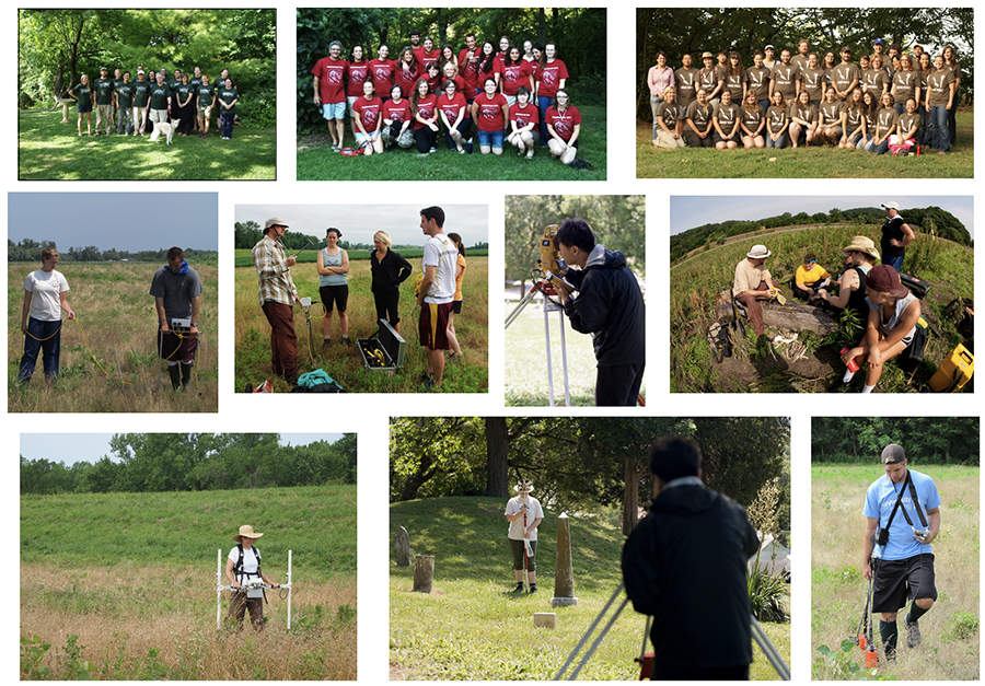
Beginning in 2008, research has integrated topographic and multi-instrument geophysical surveys into ongoing excavations and field school curricula at sites in the LIV as part of the Arizona State University Field School (ASUFS) hosted at the Center for American Archeology (CAA) in Kampsville, Illinois. Mapping and remote sensing surveys have focused on a student-centered approach wherein students enrolled in geomatics modules collect and analyze data under instructor supervision. Field data are used to teach students concepts and skills in processing and interpretation that are augmented using data from previous and concurrent excavations. These data are then made available to students for final course projects and presentations at conferences.
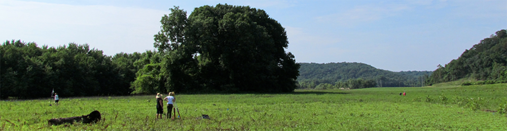
In the summer of 2013, student-based geomagnetic survey and high-density mapping were conducted at the Kamp Mounds group (11C12). Located about 30 miles north of the confluence of the Illinois and Mississippi rivers in Calhoun County, Illinois, the Kamp Mounds group is situated on the west bank of the Illinois River. It is an oval, approximately 3-hectare area originally described in 1928 and later in 1958 as composed of at least ten mounds, a portion of them situated on a large north-south sand ridge, of varying size and preservation.
LiDAR data and surface survey demonstrate that only portions of eight mounds remain, with Mounds 3 and 4 completely destroyed and Mounds 1, 2, and 5 highly disturbed by earlier road construction. The remaining mounds, with exception of the large Mound 8, been reduced in size with lateral spreading of mound sediment due to plowing. For example, Taylor’s 1928 estimates of mound dimensions of Mounds 6 and 7 are approximately 75 x 35 meters in width with a height of 5 meters. Today, Mounds 6 and 7 are roughly 70 x 30 meters in width and about 2 meters in height.
Following antiquarian excavations during the late 1880s, excavations in 1928, and in 1958, ASUFS students and CAA researchers returned to Kamp Mounds in 2013 to conduct high-density topographic and geomagnetic surveys.
TOPOGRAPHIC AND GEOMAGNETIC SURVEY
The high-density topographic survey was performed to digitally record the nature of the ground surface of the Kamp Mounds group which will serve to illustrate surface features as a baseline for other spatial data acquired from the site, including subsequent landscape change resulting from erosion, agricultural use, or other environmental factors. These data will also be useful for visualizing subtle landscape features that may not be easily recognizable on the surface.
Over the course of two-weeks, students were trained in total station use and survey methods, collecting over 45,000 data points using a Trimble 5600 Robotic Total station. The robotic station automatically tracks the roving stadia rod that the operator rolls over the landscape. The operator controls the survey by radio from a data logger and records X, Y, Z, coordinates at a rate of one measurement per second.
A Digital Elevation Model was created to illustrate the topographic surface in various ways, including a digital surface and hillshade raster. Each view offers different insights into site formation as well as historic landscape use and change, such as a large area of lower elevation and lateral mound spreading as a result of agricultural plowing and subsequent movement of soil across the site.
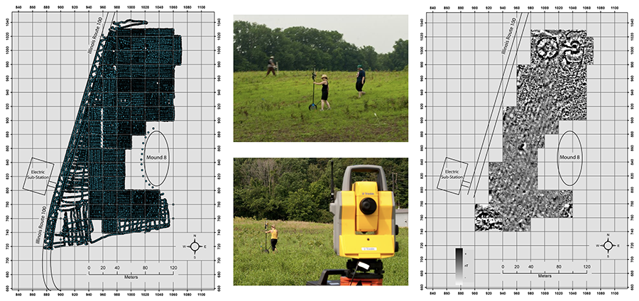
A second component of the 2013 work was a landscape scale geomagnetic survey conducted by the ASUFS students and staff. Over two-weeks we collected a total of 2.4 of the approximately 3-hectare site. The results are fairly spectacular with the presence of large geometric anomalies that correspond with Mounds 6 and 7 and within Mound 1.
Work is ongoing, not only at Kamp Mounds, but at other locations as part the LIV Survey Project. As this larger project progresses, the implementation of geophysical and topographic methods integrated within an archaeological research program focused upon the use and construction of LIV Middle Woodland multi-community spaces will continue to be important in the identification of feature locations, inform on depositional stages related to construction and use of sites, and shed light on prehistoric and historic site histories. Our ultimate goal is the collection of data at multiple scales directed toward broader interpretations of variability and use intensity at Middle Woodland sites in the Lower Illinois River Valley.
For more information:
| Buikstra, Jane E., and Douglas K. Charles 1999 Centering the Ancestors: Cemeteries, Mounds, and Sacred Landscapes of the Ancient North American Midcontinent. In Archaeologies of Landscape, edited by Wendy Ashmore and A. Bernard Knapp, pp. 201–228. Blackwell, Malden, MA. Farnsworth, Kenneth B. 2004 Early Hopewell Mound Explorations: The First Fifty Years in the Illinois River Valley. Studies in Archaeology 3. Illinois Transportation Archaeological Research Program, Urbana. King, Jason L., Jane E. Buikstra, and Douglas K. Charles 2011 Time and Archaeological Traditions in the Lower Illinois Valley. American Antiquity 76:500–528. King, Jason L., Duncan P. McKinnon, Jason T. Herrmann, Jane E. Buikstra, and Taylor H. Thornton 2017 The Role of Remote Sensing in Evaluating Structural Variation in Middle Woodland Mounds in the Lower Illinois River Valley. In Archaeological Remote Sensing in North America: Innovative Techniques for Anthropological Applications, edited by Duncan P. McKinnon and Bryan S. Haley, pp. 171-184. University of Alabama Press. |